Description
Project short description
The Mediterranean region is specifically sensitive to climate change extremes. These coastal sites share common water management problems due to their overexploitation, fresh water pollution, sea level rise, seawater intrusion and land losses. Increased complexity of policy making in these sites presents an ongoing challenge to managers.
The objective of this project is to identify the impacts of climate change on water resources in coastal zones, and how they imply, in turn, socio-economic vulnerability and sustainable development. An integrated quantitative assessment can achieve this goal by combining projections from climate change scenarios with advanced computational hydrological impact assessment models (numerical modeling and optimization workflows) to identify vulnerability hotspots.
The overall project intends to develop an integrated and multidisciplinary approach in the Mediterranean coastal areas generating integrated models for optimal water management, artificial recharge and aquifer exploitation under seawater intrusion constraints. The proposed approach will contribute to improve water resources management, control seawater intrusion into coastal aquifers, minimize pollution for efficient water use and reuse and intermediate the availability and demand on water. Moreover, the project will provide an assessment of the socioeconomic vulnerability in the coastal areas, which will be presented in the form of integrated maps that illustrate identified hotspot areas, for informing policy dialogue and decision-making on CC adaptation.
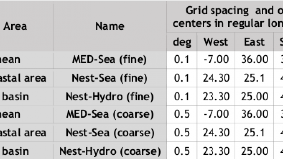
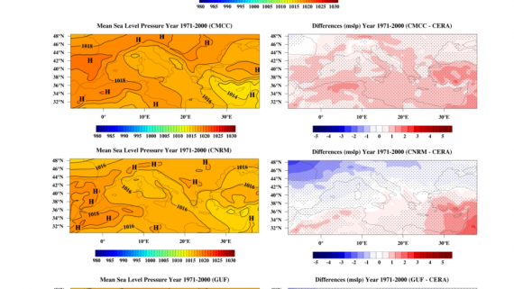
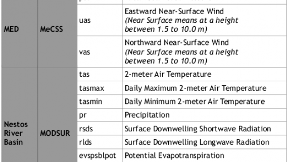
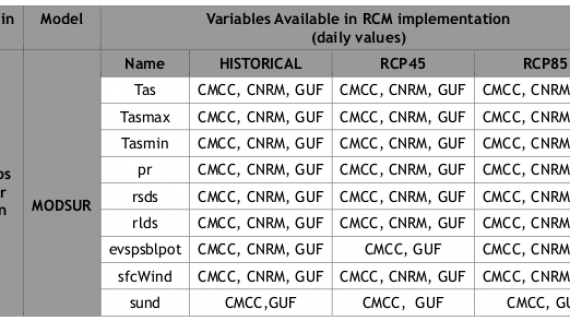
Particular emphasis will be devoted to optimal water resources management in six selected sites, including coastal aquifers to be protected from seawater intrusion and overexploitation. Climate change projections and outputs from many Global Climate Models (GCMs) will serve as a basis for generating outputs from Regional Climate Models (RCMs) at the basin scale, using statistical downscaling techniques. Based on the RCMs outputs, Regional Hydrological Models (RHMs) will draw upon global and regional databases with a view towards producing a series of regional hydrological impacts simulations for interacting surface and groundwater systems (including coastal aquifers) for different climate projections.
A socio-economic vulnerability assessment will be carried out based on the outputs of these impacts by incorporating socio-economic and environmental issues. Integrated mapping of the outputs generated from the vulnerability assessment will facilitate understanding and analysis of the findings. The project will setup simulation scenarios addressing climate change uncertainty to enhance water resources management practices and to inform decision makers on the best adaptive measures.